As temperatures rise and municipal activity ramps up, summer marks a high-stakes period for cities and towns. This season brings its own set of infrastructure demands, from handling intense storms and increased public space usage to maintaining roads and utilities during peak construction season. For municipal officials, engineers, and public works teams, the key to navigating these challenges is preparation, and today, that preparation is increasingly driven by one powerful tool: Geographic Information Systems (GIS).
GIS combines geographic data with layers of information about roads, utilities, stormwater systems, green spaces, and more. This helps municipalities visualize infrastructure networks in real time, streamline maintenance, and plan projects with precision, precisely what’s needed to stay ahead of summer demands.
- Mitigate Flooding Risks by Mapping Stormwater Vulnerabilities
Summer can bring severe rainstorms, flash floods, and heavy runoffs. Without proper management, this can lead to roadway hazards, basement flooding, or overwhelmed municipal stormwater systems.
With GIS, municipalities can:
- Identify low-lying areas prone to flooding, using elevation mapping and historical flood data.
- Monitor clogged or undersized storm drains that need maintenance before storms hit.
- Model surface runoff to understand how water will flow during major rain events.
- Prioritize drainage system upgrades based on real-time assessments and community feedback.
By layering hydrologic data with public complaints and asset locations, engineers can pinpoint where resources are most urgently needed.
GIS doesn’t just visualize the problem; it helps prevent it.
- Streamline Road and Pavement Maintenance with Condition Mapping
Hot summer weather and increased vehicle traffic can accelerate pavement deterioration. Municipalities often face tight repair windows before the fall season, making prioritization essential.
GIS offers pavement condition indexing (PCI) and mapping tools to:
- Visualize road degradation, like cracking, rutting, or potholes, across miles of township roadways.
- Overlay utilities and project schedules to avoid conflicts during resurfacing.
- Forecast repair cycles based on material performance, climate, and usage trends.
GIS-based pavement management saves time and money by enabling a data-driven approach, ensuring the worst roads are fixed first, not just the busiest or most frequent complaint targets.
- Manage Parks, Paths, and Recreation Areas During Peak Usage
Residents flock to parks, fields, trails, and community centers during summer. This seasonal uptick in outdoor activity puts pressure on recreational infrastructure, and GIS can help keep it all running smoothly.
Municipal parks and recreation departments can use GIS to:
- Inventory park assets (benches, lighting, sports facilities, etc.).
- Track maintenance schedules for fields, courts, or greenery.
- Identify dark or underused areas in need of lighting or safety improvements.
- Share interactive digital park maps online for public engagement.
For municipalities with economic development goals, this data can also support grant applications related to quality-of-life, health, or recreation funding.
- Support Small-Scale Projects and Preventive Repairs
While summer is busy, it’s also a chance to address minor issues, things like sidewalk gaps, culvert cleanouts, or alley regrading, before they become major liability concerns.
GIS empowers crews to:
- Map these “punch-list” tasks across neighborhoods.
- Assign tasks by location and easily communicate with mobile field teams.
- Create visual timelines of how infrastructure performance changes year-round.
With field apps connected to GIS, inspectors and repair crews can log updates directly onsite, a huge step up from paper maps or spreadsheets.
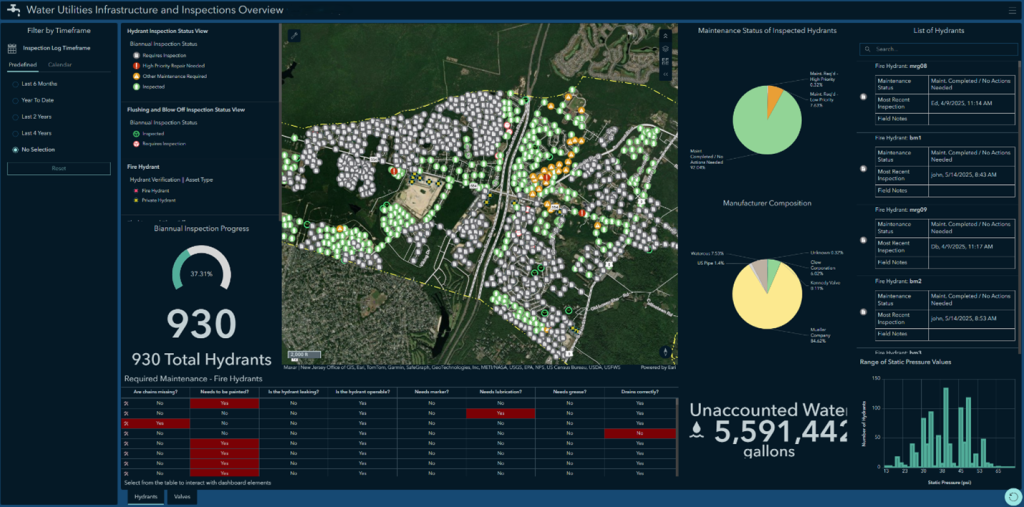
- Visualize Utility Networks to Avoid Costly Construction Conflicts
Summer isn’t just for municipal work, utility providers, contractors, and homeowners are digging too. Every excavation has the potential to disrupt buried infrastructure if systems aren’t mapped accurately.
By keeping GIS-based utility mapping updated and accessible, municipalities can:
- Quickly locate water, sewer, storm, fiber, or electric lines.
- Identify aging or undersized segments in need of replacement during planned road work.
- Share utility layers securely with project stakeholders to avoid accidental strikes.
Pairing GIS with as-built documentation and asset management systems reduces guesswork, saving time and avoiding emergency repairs that derail capital plans.
- Promote Transparency and Public Engagement Through Dashboards
One of GIS’s most valuable functions is turning complex infrastructure layers into simple, visual stories.
Summer can test public patience, whether it’s closed roads, dusty work zones, or flooded crosswalks. By publishing public-facing GIS dashboards, municipalities can:
- Display active construction areas and detours.
- Share planned maintenance schedules.
- Let residents report issues using geo-tagged apps (such as missed trash pickup or blocked storm drains).
- Increase trust by showing what’s being fixed and why.
In 2026, there’s no reason residents shouldn’t be able to pull up an interactive map showing how their local tax dollars are being invested.
- Get Ahead of Budgeting and Grant Writing Season
Summer often coincides with new fiscal years or mid-year reviews. It’s a strategic time to use GIS data to:
- Justify budget requests for infrastructure.
- Support grant applications, like NJDOT, NJDEP, or FEMA resilience funding.
- Prioritize capital improvement planning (CIP) projects based on factual analysis rather than politics or anecdotes.
GIS can combine condition scores, replacement costs, and risk data, turning infrastructure planning into a budget-conscious, transparent process.
Turning Data into Success: How Van Cleef Helps Municipalities Build Smarter
GIS isn’t new, but its role in proactive municipal management has never been more essential.
At Van Cleef, our GIS team works with municipalities, utilities, campuses, and developers to build secure, scalable systems tailored to each client’s needs. Our services include:
- Utility and stormwater system mapping
- Pavement management and condition surveys
- Asset inventory and lifecycle planning
- Mobile apps for crews and inspectors
- Public engagement dashboards
- Integration with engineering design and permitting workflows
By tapping into GIS insights, municipalities can reduce emergency calls, streamline summer work, and build more resilient communities.
View some of Van Cleef’s GIS Projects: https://tinyurl.com/5yhjy26c
Ready to Put GIS to Work This Summer?
Don’t wait for the next heat wave, sinkhole, or storm to reveal what your infrastructure already knows. Let GIS illuminate what’s working, and more importantly, what isn’t.
Contact us today to schedule a GIS consultation or to learn more about how our engineering, planning, and spatial analysis services can help your community stay one step ahead.